It’s a Bird, It’s a Plane, It’s a…DRONE!
Written by Michael McMahon, Master Student – University of Minnesota, Conservation Sciences Graduate Program.

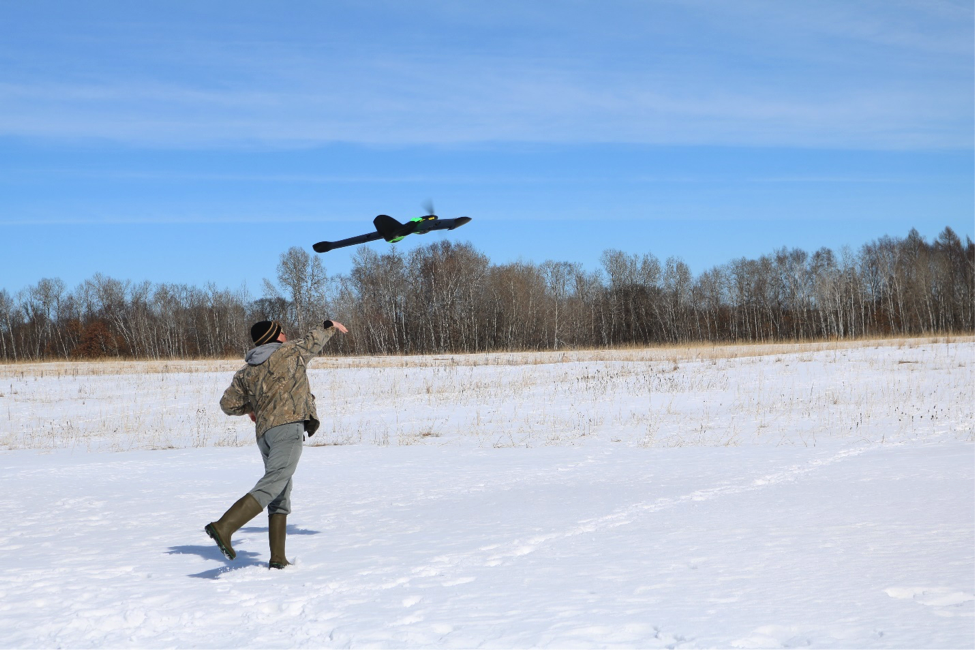
Over the last year, you may have caught a glimpse of a large green “bird” flying over parts of the Cedar Creek Ecosystem Science Reserve. This bird however is not your typical suspect of flying fauna normal to Cedar Creek! This Unmanned Aerial Vehicle, or UAV as they are called, is a drone that is being used to conduct wildlife surveys across the Cedar Creek property. I have been flying this drone for my research in the Conservation Sciences Graduate Program at the University of Minnesota, as a part of my Master’s project. I use the UAV to count and better understand the deer population at Cedar Creek, and I look forward to sharing what I learn!
For wildlife biologists to effectively make decisions about how to best manage wildlife populations, it is important to know one thing first…HOW MANY ARE THERE?! This question can be more difficult to answer than it may seem, and it is especially important for white-tailed deer. Maintaining a healthy deer herd ensures that there are not too many or too few deer on the landscape. Too many deer can lead to an area’s plant community being damaged from over-eating. It is also important to be sure that deer numbers do not get too low from harvesting during hunting seasons. This can be a delicate balance, but collecting good data can certainly help.

For this project we got to thinking, is there a better way to more accurately count wildlife??? We thought there just might be!
We are using a fixed-wing UAV, equipped with a FLIR thermal infrared sensing camera, to fly survey plots across the Cedar Creek property. Our goal is to determine if this relatively new approach is effective for estimating the population density of deer. While the drone is flying over the landscape, our camera is taking pictures that will cover the entire area that the drone flies over. This thermal camera is “seeing” heat signatures from anything down on the ground (Think of the old Predator movies!). We can then review these thermal images after the flight, and count how many deer we ended up flying over. That gives us a good start to understanding just how many deer live in or move through Cedar Creek!


But how do we know if our count is right, or even close to the true number of deer on the property? This is a good question, and one that we need to answer. To do this we are using data gathered on the ground by more conventional means to estimate the deer population, and comparing it to our findings from the UAV. One conventional method of estimating the number of deer at Cedar Creek uses pellet-group counts (Yes that’s right…we’re counting deer poop!). Another method uses the excellent camera trap data gathered by the Cedar Creek: Eyes on the Wild project. By estimating deer abundance using our UAV, pellet counts, and camera trap images, we can assess how consistent our estimates of deer abundance are and better understand if UAVs are a good tool to use.

We are very excited about our research at Cedar Creek and are pleased by our initial results. We would like to thank all of the busy citizen scientists out there for your hard work in classifying so many images. These will be so important to our own work! I look forward to sharing more results on our findings in the future, so please stay tuned to our project. And remember, if you happen to be out at Cedar Creek and you see the big green bird in the air, stop over for a chat to learn more about our research!
Hi there! This is such a fascinating post! I love how different drone types are being used for wildlife research — it’s amazing that something that looks like a bird in the sky can actually help track deer populations and gather valuable data. Using thermal imaging to spot animals seems like a really clever idea, and it’s great to see technology being applied in such a practical way for conservation. Thanks for sharing this — I’m excited to see what other insights your drone surveys uncover!
ReplyDelete